Bangkok
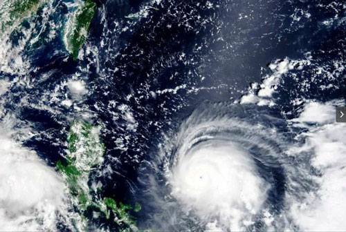
A strong typhoon skirted past most of the Philippines on Friday but appeared to be gaining strength as it headed directly for Taiwan this weekend, forecasters said.
The Philippine meteorological agency said Typhoon Chanthu was on the cusp of becoming a category 5 “super typhoon” with sustained winds of 215 kilometers per hour (134 mph) at its center and gusts up to 265 kph (165 mph) as it moved past the extreme northeastern portion of Cagayan province. A super typhoon is one with sustained winds of 220 kph (137 mph) or more.
Landfall was still not ruled out for Cagayan and authorities warned that even if the eye of the storm remained off the coast, it could bring flash floods and landslides, as well as gale to storm-force winds on shore, and cause extremely rough seas.
“Mariners are advised to remain in port or take shelter in port until winds and waves subside,” the Philippine Atmospheric, Geophysical and Astronomical Services Administration said.
Current forecasts are that it will most likely hit the east coast of Taiwan on Sunday morning, with the potential of hitting the island head-on if it tacks more to the west, or missing it entirely if it veers to the east.
Taiwan’s Central Weather Bureau has issued a typhoon warning as it tracks the storm. The bureau said high waves were expected along Taiwan’s southern coast and in the Bashi Channel between its southern tip and the northernmost island in the Philippines.
“The likelihood that this typhoon will reach super typhoon category is not ruled out,” the Philippine Atmospheric, Geophysical and Astronomical Services Administration said in its Friday evening bulletin.
“On Sunday, weakening trend may begin as the typhoon interacts with the rugged terrain of Taiwan but will remain within typhoon category.”
The agency added that “public and disaster risk reduction and management offices concerned are advised to take all necessary measures to protect life and property.”
On its current course, the typhoon is not expected to hit mainland China but has the potential to by Monday if it moves more westward than currently expected.—AP


