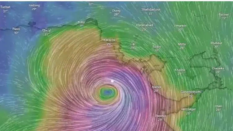
Cyclone has ‘slowed down’, landfall expected after midnight: Sherry
The landfall of Cyclone Biparjoy, currently classified as a “very severe cyclonic storm”, commenced along the Indian Gujarat coast and the Pakistan-India border at 7pm on Thursday, according to the Pakistan Meteorological Department (PMD).
The PMD said the cyclone had moved further east-northeastward during the last three hours and its landfall would be complete by midnight.
In a tweet, Climate Change Minister Sherry Rehman said Biparjoy had reportedly made landfall in Indian Gujrat.
“It is still at a distance from Pakistan, and will likely begin counterclockwise landfall around or after midnight in our coastal areas. The sea may be rough with high waves at the core. Please stay safe,” she added.
PMD says landfall of cyclone has commenced, Biparjoy now at 245km south of Karachi, 200km south of Thatta and 150km south-southwest of Keti Bandar
Sherry Rehman says cyclone “slowed down” and won’t make landfall before night
Over 80,000 people have been evacuated; possibility of another cyclone in July; rain reported across Sindh
Sindh CM puts administrations of Karachi, Hyderabad on alert.
100,000 people evacuated in India’s western state of Gujarat
In its latest alert, the PMD said the cyclone now lies near latitude 22.9°N and longitude 68.2°E at a distance of about 245km south of Karachi, 200km south of Thatta, and 150km south of Keti Bandar.
It added that the cyclone would bring winds between 100-120km/h with gusts up to 140km/h with maximum wave height of 20-25 feet.
The alert said that widespread wind-dust/thunderstorm and heavy rain was likely in Sindh’s Thatta, Sujawal, Badin, Tharparkar, Mirpurkhas, and Umerkot districts from June 15-17.
It further predicted dust/thunderstorms and rain accompanied by squally winds in Karachi, Hyderabad, Tando Muhammad Khan, Tando Allayar, Shaheed Benazirabad, and Sanghar districts today and tomorrow (Friday).
It added that dust/thunderstorm and isolated heavy rainfall was likely in Balochistan’s Hub, Lasbela, and Khuzdar districts today and tomorrow.
The weather alert said that a storm surge of 3-4 metres was expected at Keti Bander, where the cyclone will make landfall, and its surroundings.
“Sea conditions along Sindh coast may get very rough/high (2-2.5m) and rough/very rough (2m) along Balochistan coast (Sonmiani, Hub, Kund Malir, Ormara and surroundings),” it added.
Earlier, Sherry Rehman said the cyclone had slowed down but the “core remains intense”.
“It will not make landfall before nightfall now. More information will be shared soon from the National Disaster Management Authority,” she tweeted.


