Islamabad
India faced yet another embarrassment at the hands of relatively far small neighboring country, Nepal, after Kathmandu formally introduced to school curriculum its revised political map with strategically important areas, claimed by India, as the country’s part.
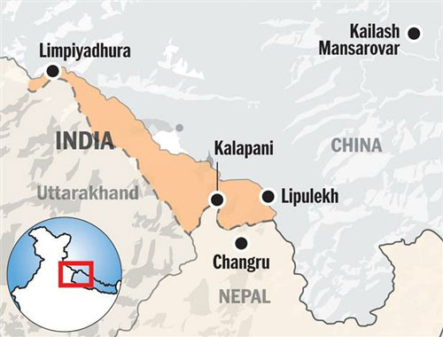
The Nepali Parliament on June 13, 2020, unanimously approved the new map of the country featuring the Lipulekh, Kalapani and Limpiyadhura areas, which India claims belongs to it, Kashmir Media Service reported.
Kathmandu has introduced new textbooks in the school curriculum that include the country’s revised political map showing the above said three strategically-important areas as part of its territory.
The Curriculum Development Centre, under the Ministry of Education, recently published the books with the revised map, information officer at the centre Ganesh Bhattarai said.
The new books titled ‘Nepal’s territory and reading materials for border issues’ for classes IX and XII have a preface written by Education Minister Giriraj Mani Pokharel.
Following the endorsement of the new map by the Nepal Cabinet, then government spokesperson and Finance Minister Yuvaraj Khatiwada told the media that the government had decided to update the schedule of the Constitution and school curriculum incorporating the new political map.
The India-Nepal ties deteriorated after Indian Defence Minister Rajnath Singh inaugurated an 80-km strategically crucial road connecting the Lipulekh Pass with Dharchula near Uttarakhand on May 8.
At a time when Nepal and India were seeing some positive gestures in the resumption of dialogue after months-long deadlock due to a “cartographic war”, the government on Tuesday released “a reference book” for school students, which dwells on border disputes, mainly with the southern neighbour, in a move that could further shrink the space for bilateral talks.
The publication of the book, according to Minister for Education Giriraj Mani Pokharel, was triggered by the Indian government’s move on November 2 last year to publish its political map depicting Kalapani within Indian borders. Nepal claims Kalapani as its own territory.
The two countries, however, reached a state of cartographic war in May when Indian defence minister inaugurated a road link via Lipulekh to Kailash Mansarovar in the Tibet Autonomous Region of China.—APP


