Bai Yunyi
Beijing
The buildings that some in Nepal have accused China of encroaching on its land in Humla district falls within Chinese territory and is actually a newly-built village in Burang county in Ali, southwest China’s Tibet Autonomous Region, a Burang county official told the Global Times in an exclusive interview on Friday.
Baci, the foreign relations office director of Burang county, said that before construction started in May, military and local professional surveying and mapping personnel made detailed field measurements to ensure that the village would be built on the Chinese side.
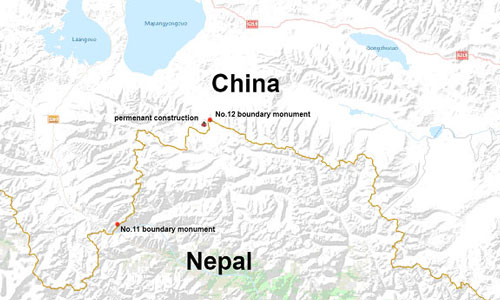
The village completely falls within Chinese territory, and the nearest building is a kilometer away from the China-Nepal border, Baci said, adding that construction of the new village is nearly finished.
Professional surveying personnel in Ali conducted a second field measurement after some Nepalese people raised questions, and they confirmed that all buildings are located in Burang county, Baci said.
The village was built to boost border trade, and there was no friction or dispute with Nepalese border troops during the construction process, he said. Citing a Nepalese inspection team organized by the local opposition party, some media outlets reported that the buildings were built two kilometers inside Nepalese land, and had crossed the border at Pillar 12. However, the new village was built between Pillar 11 and 12. A source close to the matter told the Global Times on Friday that Pillar 11 and 12 are very high in altitude and far away from each other. The border line was drawn according to the trend of the mountains, so it is very erratic and easy for non-professional surveyors to make mistakes.
He said it’s likely that the Nepalese surveying team made a technical error. The Chinese and Nepalese governments have conducted three joint border inspections since their border was determined and did not find any problems, he said.
The border between China and Nepal has been formally delimited, and there is no territorial dispute between the two countries.
According to the China-Nepal border treaty, the borderline between Pillar 11 and 12 follows the Mapchu (Karnali) River and runs northeastwards along the mountain spur up to Chialosa (Takule), and passes through Kumalatse (Kuma lapche),
Kangpaochekuo (Ghanbochheko) and Mainipaimikuo (Manepamango) to Kangkuona (Kangarje), then northwards through Kangchupeng (Kandumbu) and at 6,550 meters to Nalakankar. –Courtesy Global Times Published


